


Mô tả của BackCountry Navigator XE: Outdoor GPS App (New)
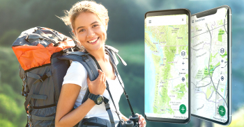
Welcome to the next generation of a product for exploring the outdoors on your own terms, using offline topo maps and GPS on your smartphone.
You can also subscribe to the XE List to get notified of status, updates, and deals.
While many of the goals of the new app are the same, we are hoping to achieve a number of goals with the new platform:
Cross-Platform
The original BackCountry Navigator PRO is only available on Android. We will be bringing BackCountry Navigator XE to Android, iOS and the web.
The corresponding app for iOS will be launched through TestFlight
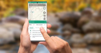
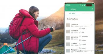
Planning In The Cloud
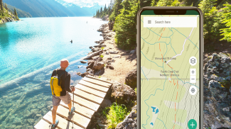
The website bcnavxe.com is the web interface for BackCountry Navigator XE. With it you can plot points, routes, and boundaries for trips, and download them on demand in the mobile app. You can push trips created in the mobile app to the cloud as well for reviewing or sharing.
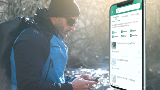
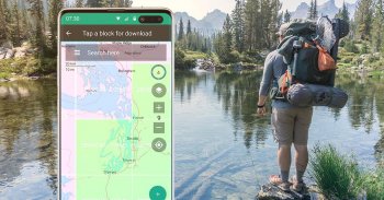
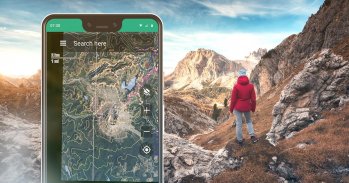
Easy Grid Based Download of Maps
You can try out a simpler approach for downloading and organizing offline maps, choosing large squares at a time. Visualize what you have and what you need.
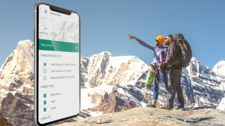
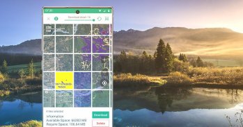
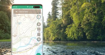
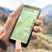
Vector Topo Maps for the World
Vector topo maps for the world hold the promise of crisp multilevel detail, with the ability to download large chunks of the earth's surface in a quick, compact operation. The BackCountry topo map for the world can be viewed in this app and on bcnavxe.com, with an easy process to install them in large blocks.
SALE: 5 and 10 year plans now available for a limited time at bcnavxe.com.
Use coupon SUB2020 to save even more before the end of the month.
If you are looking for an already proven and established product, also consider BackCountry Navigator PRO. Support and development of that app continues on a parallel track.
https://play.google.com/store/apps/details?id=com.crittermap.backcountrynavigator.license
Chào mừng bạn đến với thế hệ tiếp theo của một sản phẩm để khám phá ngoài trời theo cách riêng của bạn, sử dụng bản đồ topo ngoại tuyến và GPS trên điện thoại thông minh của bạn.
Bạn cũng có thể đăng ký Danh sách XE để được thông báo về trạng thái, cập nhật và giao dịch.
Mặc dù nhiều mục tiêu của ứng dụng mới là giống nhau, chúng tôi hy vọng sẽ đạt được một số mục tiêu với nền tảng mới:
Đa nền tảng
BackCountry Navigator PRO ban đầu chỉ khả dụng trên Android. Chúng tôi sẽ đưa BackCountry Navigator XE lên Android, iOS và web.
Ứng dụng tương ứng cho iOS sẽ được ra mắt thông qua TestFlight
Lập kế hoạch trong đám mây
Trang web bcnavxe.com là giao diện web cho BackCountry Navigator XE. Với nó, bạn có thể vẽ các điểm, tuyến đường và ranh giới cho các chuyến đi và tải xuống theo yêu cầu trong ứng dụng di động. Bạn có thể đẩy các chuyến đi được tạo trong ứng dụng di động lên đám mây để xem xét hoặc chia sẻ.
Tải xuống bản đồ dễ dàng dựa trên lưới
Bạn có thể thử một cách tiếp cận đơn giản hơn để tải xuống và sắp xếp bản đồ ngoại tuyến, chọn các ô vuông lớn tại một thời điểm. Hình dung những gì bạn có và những gì bạn cần.
Bản đồ Vector Topo cho thế giới
Các bản đồ vector topo cho thế giới hứa hẹn về chi tiết đa cấp sắc nét, với khả năng tải xuống các khối lớn của bề mặt trái đất trong một hoạt động nhanh chóng, nhỏ gọn. Bản đồ topo BackCountry cho thế giới có thể được xem trong ứng dụng này và trên bcnavxe.com , với một quy trình dễ dàng để cài đặt chúng trong các khối lớn.
BÁN: Các kế hoạch 5 và 10 năm hiện có sẵn trong một thời gian giới hạn tại bcnavxe.com.
Sử dụng phiếu giảm giá SUB2020 để tiết kiệm nhiều hơn trước cuối tháng.
Nếu bạn đang tìm kiếm một sản phẩm đã được chứng minh và thành lập, hãy xem xét BackCountry Navigator PRO. Hỗ trợ và phát triển ứng dụng đó tiếp tục theo dõi song song.
https://play.google.com/store/apps/details?id=com.crittermap.backcountrynavigator.license
BackCountry Navigator XE: Outdoor GPS App (New) - Phiên bản 2.8.1
(03-09-2023)BackCountry Navigator XE: Outdoor GPS App (New) - Thông tin APK
Phiên bản APK: 2.8.1Gói: com.crittermap.backcountrynavigator.xePhiên bản mới nhất của BackCountry Navigator XE: Outdoor GPS App (New)
Ứng dụng cùng danh mục
Bạn cũng có thể thích...


